Dutch weather company StormPlatform launches revolutionary weathermodel with 1K resolution and six intervals per hour
Good news: Predicting severe weather more accurate with StormCaster
De Bilt, The Netherlands, Thursday 17 August 2023
Dutch extreme weather company StormPlatform has launched today a revolutionary weather model named ‘ÍCON-D2@1K’, with an ultra high resolution of 1 kilometer and with six intervals per hour. A Dutch-, Belgian-, German-, European- and probably even a world première!
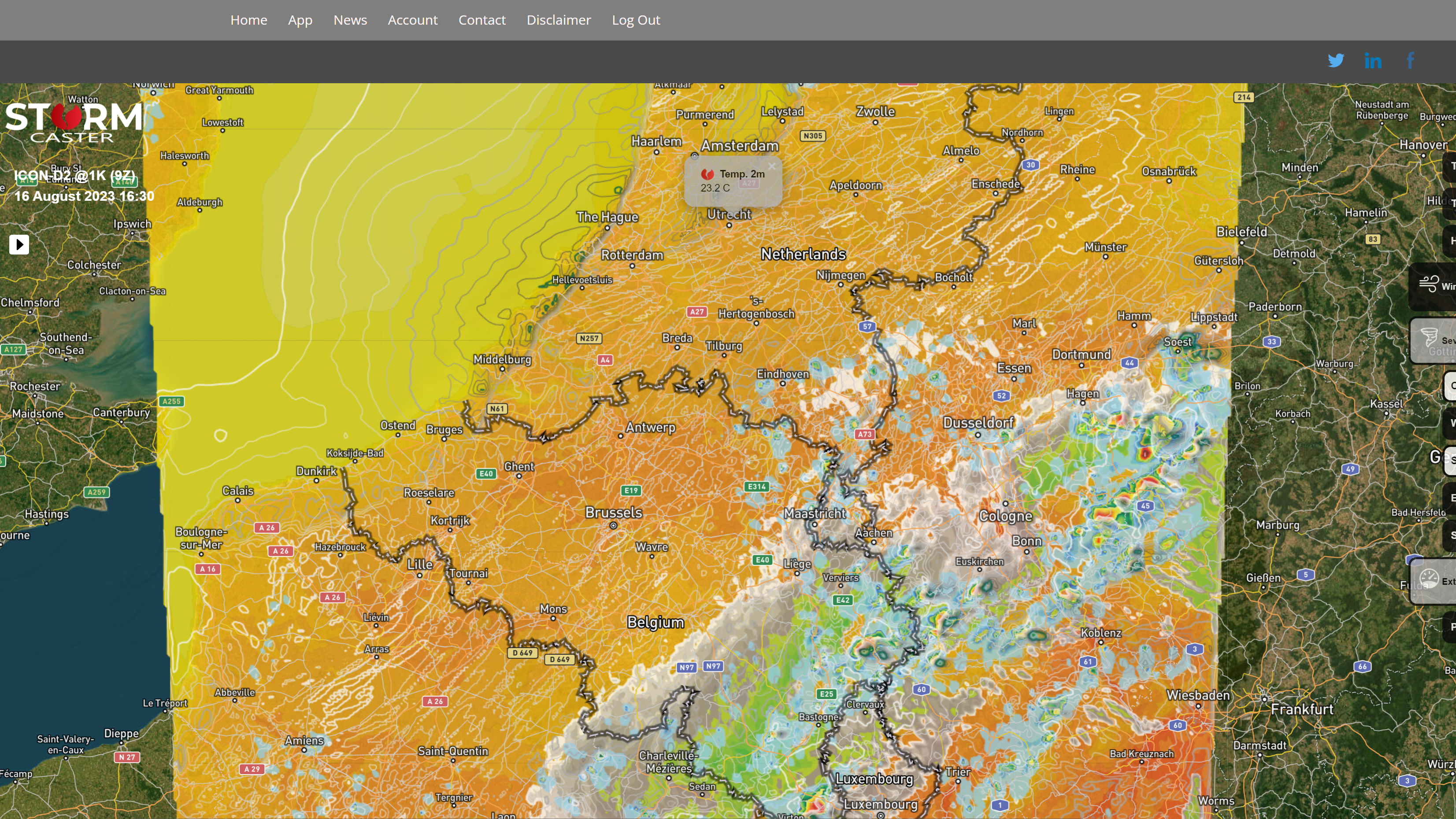
With ICON-D2@1K users of this UHR weather model can predict in the short term severe thunderstorms even more accurately than has been the case so far by regular high-resolution weather models. In theory, with this ICON-D2@1K can be ‘warned’ earlier and more precisely for local extreme weather, such as severe thunderstorms, severe wind gusts, heavy rain, large hail (> 2cm) and even for tornadoes.ICON-D2@1K is visualized on a web application called StormCaster, an interactive map with which can be quickly zoomed in on the local level on the various parameters.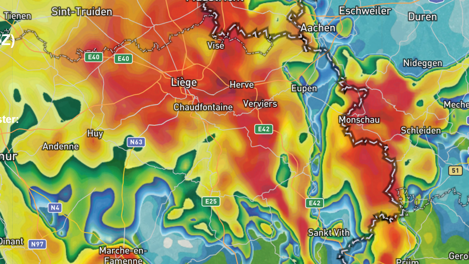
With simulated radar reflectivity you can notice the predicted intensity of precipitation in detail
Parameters such as the temperature at 2 meters height, the simulated radar reflectivity at ground level, the expected precipitation per hour in mm/h, the expected total precipitation in mm, the possible hail size, the amount of Convective Available Potential Energy (CAPE), the wind shear and the average wind at 10 meters altitude. With the help of these parameters the weather for the coming hours can already be predicted fairly well to really good. The public can also easily make their own weatherforecasts this way easily. Is it going to rain? How much wind I can expect in my region? Can I expect severe weather?
StormPlatform independently calculated parameters such as Storm Relative Helicity (SRH), Significant Tornado Parameter (STP) and Maximum Windgusts, which allow the areas that are at increased risk of extreme weather to be marked hours in advance. These parameters are normally not available from the Deutscher Wetterdienst. In particular, the SRH parameter has already proven its worth during the test phase of ICON D2@1K, by simulating an approximate tornado twice. Please note: hours in advance!
On 22 June 2023 StormPlatform was able to warn a few hours in advance that the east of Belgium and the south of Dutch region Limburg were having an increased risk of tornadoes. Later it turned out to be that a pretty heavy tornado had occurred in the southern part of the Ardennes. A relatively weak tornado was observed in the south of Limburg that afternoon.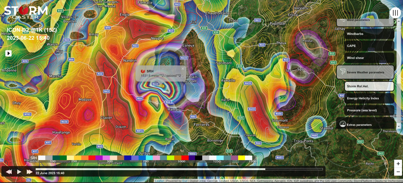
UHR weather model ICON-D2@1K is based on a ’tornadocase’ in the northwest of France on October 23, 2022. A simulated run of ICON D2@1k (15Z, 5 p.m. local time) predicted that tornadic supercell, with a tornado that had a track of no less than 145 kilometers, within ten kilometers and within ten minutes relative to reality, it turned out after analysing this case. ,,We ourselves were stunned by that result. We knew this was ‘big’‘, says Michel Brands, CEO of StormPlatform and initiator of StormCaster with ‘ICON-D2@1K’.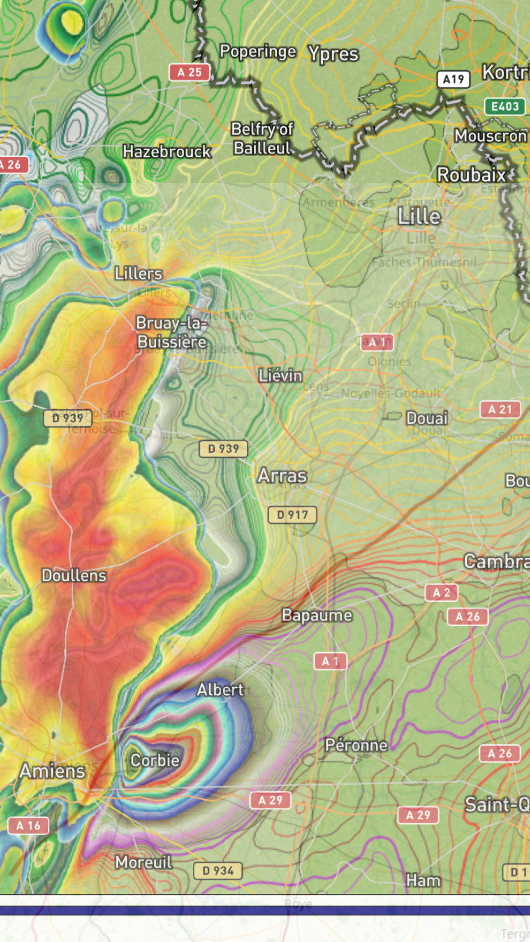
The ‘hookecho’ of the simulated tornadic supercell on October 23, 2022 in northwestern France. Storm Relative Helicity (SRH) is a measure of the potential for cyclonic updraft rotation in right-moving supercells. ICON-D2@1K’s SRH is calculated for the lowest 3 kilometer above ground level. The red line is the track of the EF2-tornado which occured on this occasion (scource: Keraunos.org), a track over 145 kilometer in total.
ICON-D2@1K is, according to Brands, therefore a big step forward in the field of short-term weather forecasts based on high resolution weather models. “You notice much more detail in the output with this ‘accelerated’ weathermodel than with normal high-resolution weather models such as HARMONIE AROME (resolution 2.5 km) of the KNMI and ICON-D2 (2.2 km) of the Deutscher Wetterdienst. The values of the various parameters are also displayed more accurately. With ICON D2@1K you can even see storms that are ‘missed’ by the current weather models and that will also not return to the output later.”
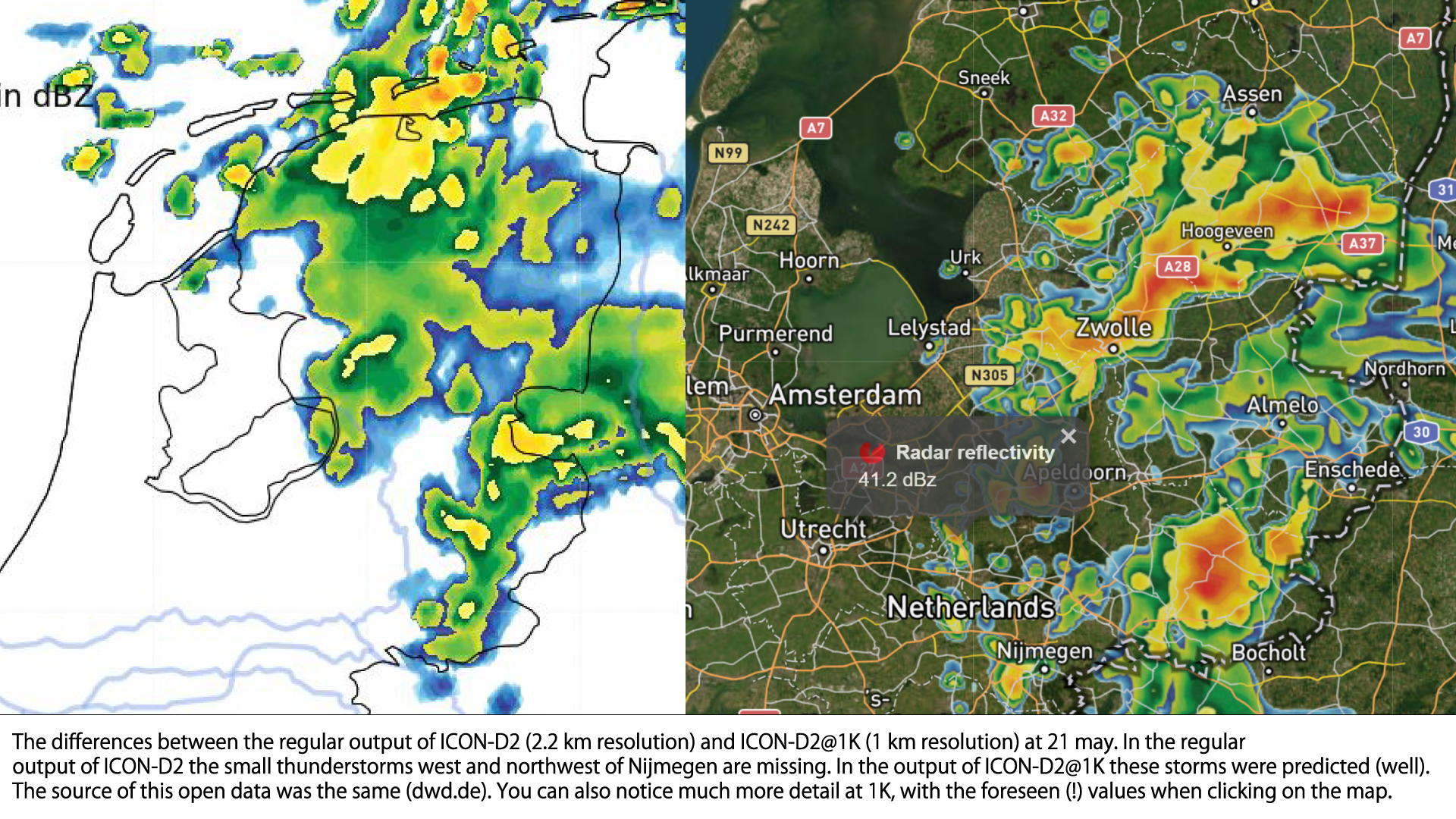
Brands added: “By using six intervals per hour, compared to normally one interval per hour, you can also better anticipate and monitor the development of those storms. The practical results of ICON-D2@1k are very promising so far. I almost don’t believe that a weather model can predict the weather so delicately these days. That was completely unthinkable for me more than eleven years ago, when I started as an active stormchaser. I honestly think ICON-D2@1K is the best weathermodel right now in Europe and maybe even beyoind for predicting extreme weather on a local scale to date.”
StormCaster is a cloud-based application that can be accessed on a PC, laptop, tablet, or any handheld device. StormCaster can or even should be used in industries such as, national weather services, government departments, emergency services, commercial weather companies, energy companies, traffic management, meteorologists, news media, weather amateurs, stormchasers, outdoor sports, construction, agriculture, public event organization, coast guard, shipping, logistics etc., and for anyone who wants to know what to expect from the weather in the next hours to day-ahead, more accurate than ever.
StormCaster (with ICON-D2@1K) is especially designed to detect extreme weather as timely and accurately as possible, (down to the regional and even local level) and the weather in the next few hours in detail, especially for offering (more) actual, (more) detailed and (more) local weather warnings. 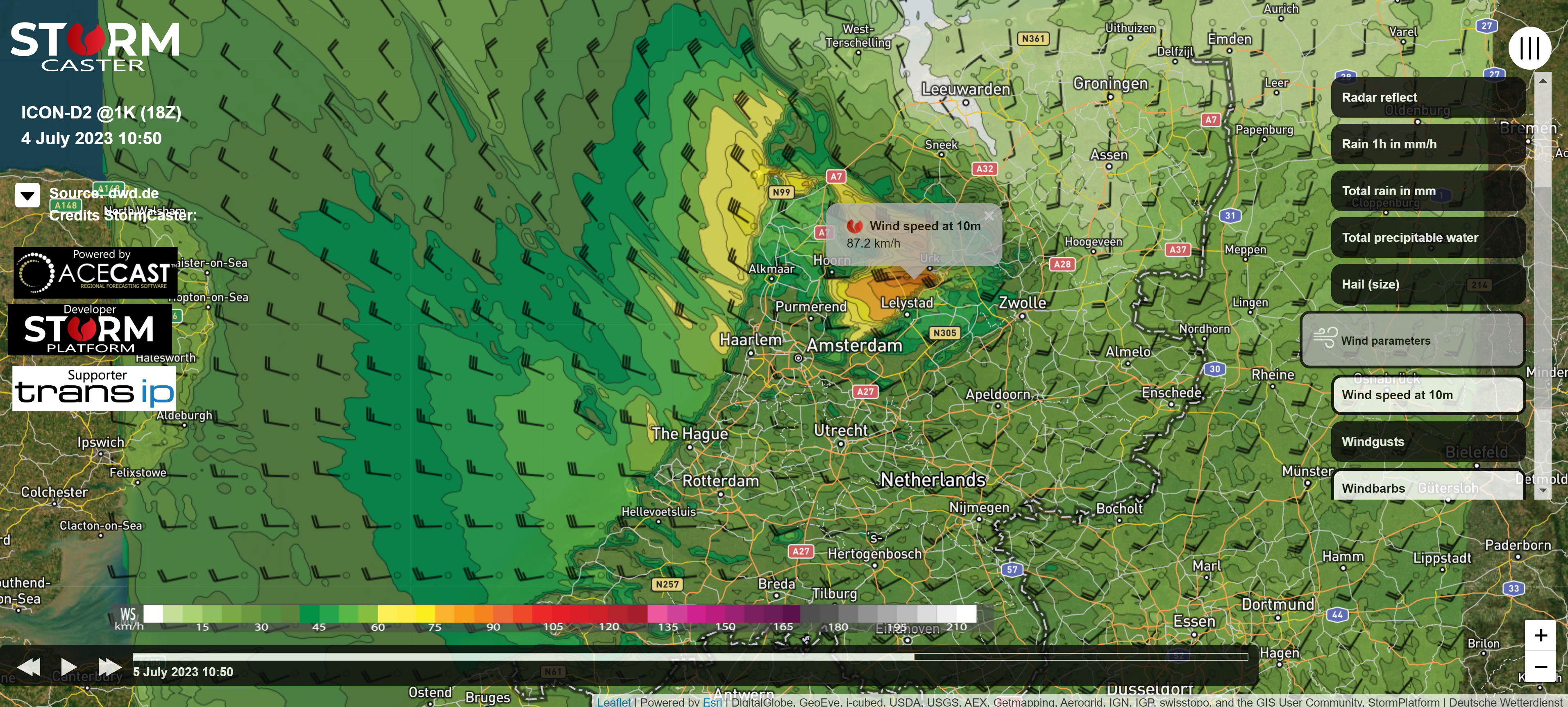
Storm Poly on the 5th of July caused a very narrow band with high speed winds, On the evening before
that small but really nasty storm was predicted really well by ICON-D2@1K
Stormcaster is based on the high-resolution weather model ICON-D2 from the Deutscher Wetterdienst (dwd.de). Storm Platform has been in collaboration with Boulder, Colorado USA-based start-up, TempoQuest to downscale the ICON-D2 model to a 1-kilometer horizontal resolution using novel GPU-accelerated Numerical Weather Prediction. This GPU-Acceleration allows for accurate, timely and frequent weather forecasts making StormCaster plus ICON-D2@1K a reality.
In this initial phase, StormCaster is only available for the Benelux and parts of north-western Germany and northern France. As soon as we have enough subscribers in the Netherlands, Belgium and Luxembourg, we plan to expand to other parts of Western Europe. We initially only offer a subscription for 30 days and for 6.99 euros including VAT. For organizations, small, big or bigger businesses and.or companies that can deduct their VAT, therefore, that means an amount of just 5.78 euros per month per account. We like to offer other subscriptions (week and year) as soon as possible.
For questions about StormCaster with ICON D2@1K please contact us
StormPlatform (StormCaster) represented by Michel Brands
E: info@stormcaster.eu or inflow@stormplatform.nl
Tel: 0031(0) 643987182